Sensor Capabilities Overview
Versatility Beyond the Payload
While the sensors featured below represent our core in-house capabilities, they’re only part of what we offer. Our team has successfully integrated and flown a wide range of advanced sensors across multiple platforms — including:
- Ground Penetrating Radar (GPR)
- Multispectral Imagers
- Bathymetric LiDAR
- Other custom and specialized payloads
Whether the mission calls for subsurface detection, vegetation analysis, waterborne mapping, or a custom-engineered solution, we have the technical expertise to adapt and deliver.
LiDAR
YellowScan Vx20 Series
High-Precision UAV LiDAR System
The YellowScan Vx20 Series is YellowScan’s most accurate, fully integrated UAV LiDAR system. Built for high-demand aerial mapping missions, it delivers exceptional precision and consistent, high-fidelity point cloud data.
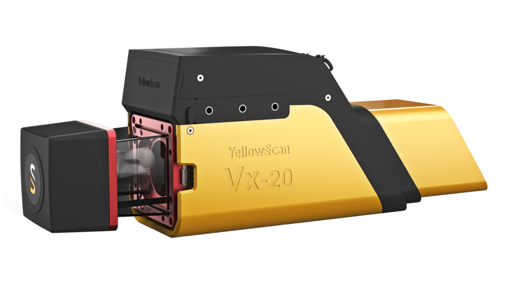
| Specification | Details |
| Precision | 1 cm (0.4″) |
| Absolute Accuracy | 2.5 cm (1″) |
| Laser Range | Up to 170 m |
| Laser Scanner | RIEGL miniVUX-3UAV |
| GNSS/IMU | Applanix APX-20 UAV |
| Field of View | 360° |
| Echoes per Shot | Up to 5 returns |
| Shots per Second | Up to 200,000 |
Magnetometry
Geometrics MagArrow
Lightweight Airborne Magnetometer Ideal for UXO detection, utility mapping, and geologic surveys. Its lightweight design allows for efficient magnetic surveys over challenging terrain.

- Magnetometer Type: Cesium vapor (Scintrex CS-3)
- Sensitivity: 0.007 nT/√Hz at 1 Hz
- Sampling Rate: Up to 1,000 Hz
- Weight: ~3.6 kg (with electronics & battery)
- Data Output: Total magnetic field
- Best For: UXO detection, pipeline locating, geologic mapping
MagNify Magnetometer
High-Resolution Magnetic Sensing Platform
Modern, UAV-ready system delivering precise magnetic field data for environmental, energy, and infrastructure applications.

- Magnetometer Type: Fluxgate or optically pumped
- Sensitivity: < 0.1 nT
- Sampling Rate: 200–1000 Hz
- Design: Modular, lightweight
- Features: Real-time data streaming, GPS georeferencing
- Best For: Infrastructure locating, mineral exploration, anomaly detection
Photogrammetry
Wingtra One Gen II + Sony RX1R II Payload
High-Precision VTOL Mapping Drone
A cutting-edge fixed-wing drone with a full-frame camera for wide-area survey and photogrammetric accuracy.

| Specification | Details |
| Camera | Sony RX1R II – 42 MP Full-Frame |
| GSD @ 55 m AGL | ~0.7 cm/px |
| Coverage @ 55 m | ~100 hectares |
| GSD @ 120 m AGL | ~1.5 cm/px |
| Coverage @ 120 m | ~210 hectares (≈520 acres) |
| Horizontal Accuracy (PPK) | Down to 1 cm RMS (no GCPs) |
| Vertical Accuracy (PPK) | Down to 2 cm RMS |
| Platform Type | VTOL Fixed-Wing (Tailsitter) |
Heavy-Lift Platform
Skyfront Perimeter 8
Long-Endurance Hybrid Multirotor UAV
Gas-electric hybrid UAV with unmatched endurance and payload flexibility. Ideal for long-range, heavy sensor missions.

| Specification | Details |
| Endurance (no payload) | Up to 2+ hours |
| Payload Capacity | Up to 10 kg (22 lb) |
| Power System | Fuel-injected hybrid-electric |
| Transport | Quick-detach arms & case |
Why It Stands Out:
- Unmatched flight time for long linear surveys
- Heavy-lift for LiDAR, magnetometers, GPR
- NDAA-compliant, non-Chinese manufacturing
- Robust telemetry & rapid deployment
- Optimized for BVLOS operations
GNSS Surveying
Trimble R10 – Base & Rover GNSS System
Complete High-Precision Ground Control Solution
Our Trimble R10 setup includes both a base station and rover receiver, enabling us to establish our own control, perform RTK surveys, and achieve centimeter-level accuracy — even in remote areas. This system enhances the precision of aerial mapping deliverables by tying them directly to verified ground truth.

